AI solutions
What we do
Services
Experts in
How we work


More than 316 million US citizens have geolocation-powered smartphones in their pockets. Most of them don’t turn off geolocation, as it is convenient to always have direct access to location details, discover places of interest nearby, or receive location-specific services and offers.
For businesses, overlooking this user behavior trend can be a mistake. Taking into account users’ location or providing users with access to location-based features can, on the one hand, help make your services more valuable and improve customer satisfaction and, on the other hand, create a more accurate picture of your buyer persona. Altogether, location-based functionality can build good ground for your business and accelerate its growth.
From on-demand apps like Uber to real estate platforms like Redfin, every software has a chance to provide the best value to customers using insights from location data. The trick is to identify the right location-based features to meet users’ needs and know how to build a robust solution. Today, we will show you how to create a location-based app tailored to your business goals and customer needs.
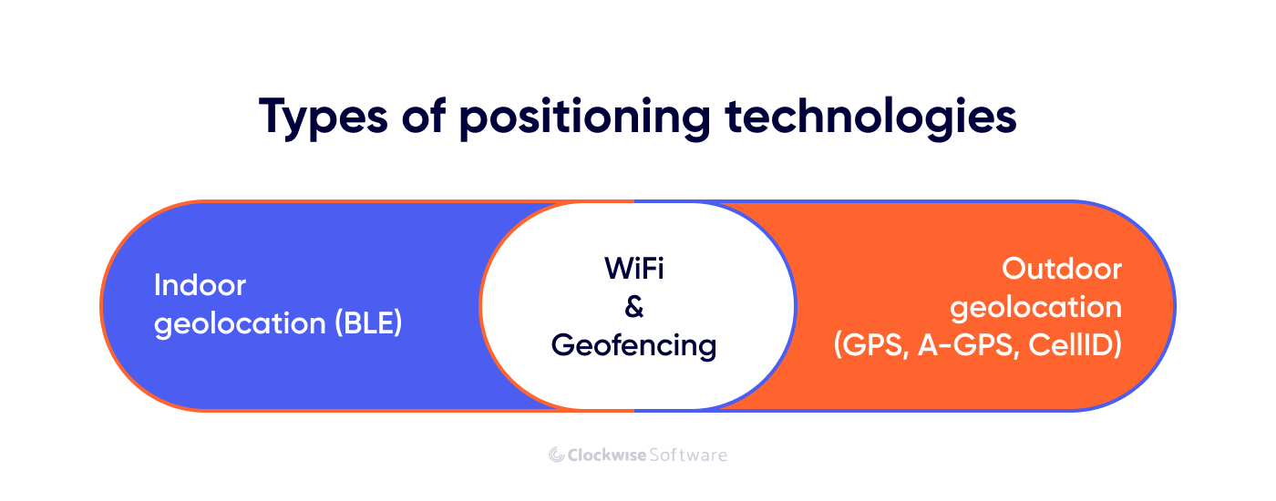
First of all, let’s see what is hidden behind location awareness. We can build location-based apps and use location intelligence because of two major categories of positioning technologies:
They help us detect objects’ location in outdoor and indoor spaces and act as the primary source of location data that we can use for various purposes, from finding a place, a person, or a service nearby to providing location-specific services to our users.
Let’s learn more about common positioning systems.
Among the technologies used to detect geolocation outdoors are GPS, Cell ID, and A-GPS. What’s the difference between them, and how do they complement one another? We can answer these questions by defining how each technology works.
GPS, or Global Positioning System, is the most common technology that helps us find information on an object’s real-time positioning through satellites. Mobile devices have a built-in GPS module. Once geolocation is activated, a device sends signals to several satellites. GPS method is a fast way to get accurate location details. However, it consumes a lot of energy. So, if you always have your GPS turned on, your device’s battery life is shorter.
When GPS is disabled or some factors, like bad weather conditions, influence the GPS signal, Cell ID comes into play. Once the signal becomes too weak to be detected by GPS, cell towers provide the signal data. The nearest mobile station receives your smartphone coordinates and helps to determine the exact location. Unfortunately, it isn’t as accurate as GPS.
…stands for Assisted GPS. It combines signals obtained from satellites and cell tower data. Its high speed and economical power consumption make it one of the most popular technologies for geolocation. Also, it may be more expensive than GPS as network providers may charge an extra fee for cell tower data access.
Outdoor positioning technologies are ineffective when you need to locate an object or a person inside a building. Walls, roofs, and other building structures may block the signal needed for GPS to detect a precise location, resulting in inaccurate positioning.
What can you use to determine a location inside a building? The answer is Bluetooth low energy (BLE) technologies.
BLE technology allows different devices with built-in Bluetooth to exchange data over short distances. It is the same as Bluetooth but uses much less energy which benefits a device’s battery life.
We can identify locations with BLE thanks to special devices called beacons. Beacons are small wireless devices that transmit a signal with a unique ID number. Mobile devices with built-in Bluetooth can identify this signal and help to detect your location based on the known location of beacons nearby. The most common formats in which beacons transmit a signal (communication protocols) are iBeacon by Apple and Eddystone by Google.
How can you use the information obtained with beacons? Well, there are numerous use cases: you can show users their precise location within a building, send tailored notifications triggered by users’ location, or help users navigate to a desired location. Beacons are easy to install and can be placed all over a building; however, they require continuous support.
Location-based apps can also use technologies that enable both outdoor and indoor positioning: Wi-Fi and geofencing. Here’s what you need to know about them.
Depending on the Wi-Fi network a user connects to, their approximate location is detected. As the Wi-Fi network covers a smaller area than GPS or cell towers but larger than beacons, it is less precise than the methods mentioned above. However, Wi-Fi positioning has its benefits: it’s less energy-consuming technology than GPS and more cost-effective than beacons. You can also use Wi-Fi in combination with other technologies to provide accurate location information in various environments.
Geofencing is a service that triggers once a smartphone crosses a virtual border (usually predefined by those who use this technology). When a device enters or leaves the limited geofencing area, this triggers a specific action, such as sending a notification with special offers to a device or sending an alert that indicates, for example, a vehicle leaving a designated area.
Geofencing use cases are numerous. However, this technology is prevalent for marketing and advertising needs. Companies even claim to multiply their marketing campaigns’ effectiveness ten times using geofencing.
Now that you know how your location-based app can collect data, let’s see why the topic is so hot.
The demand for high-quality location-based services apps is increasing daily. The reason for this is our desire for convenience in everything: a cab that arrives right at our current location, the ability to check restaurants nearby, or the ability to get pre-ordered products from a local grocery store delivered right to our homes. Services based on location information are what can offer this convenience to users.
How exactly can you improve your services with location-based features? Each industry has its use cases for spatial data. Below, you can find some use cases in industries where location-based app development is a must.
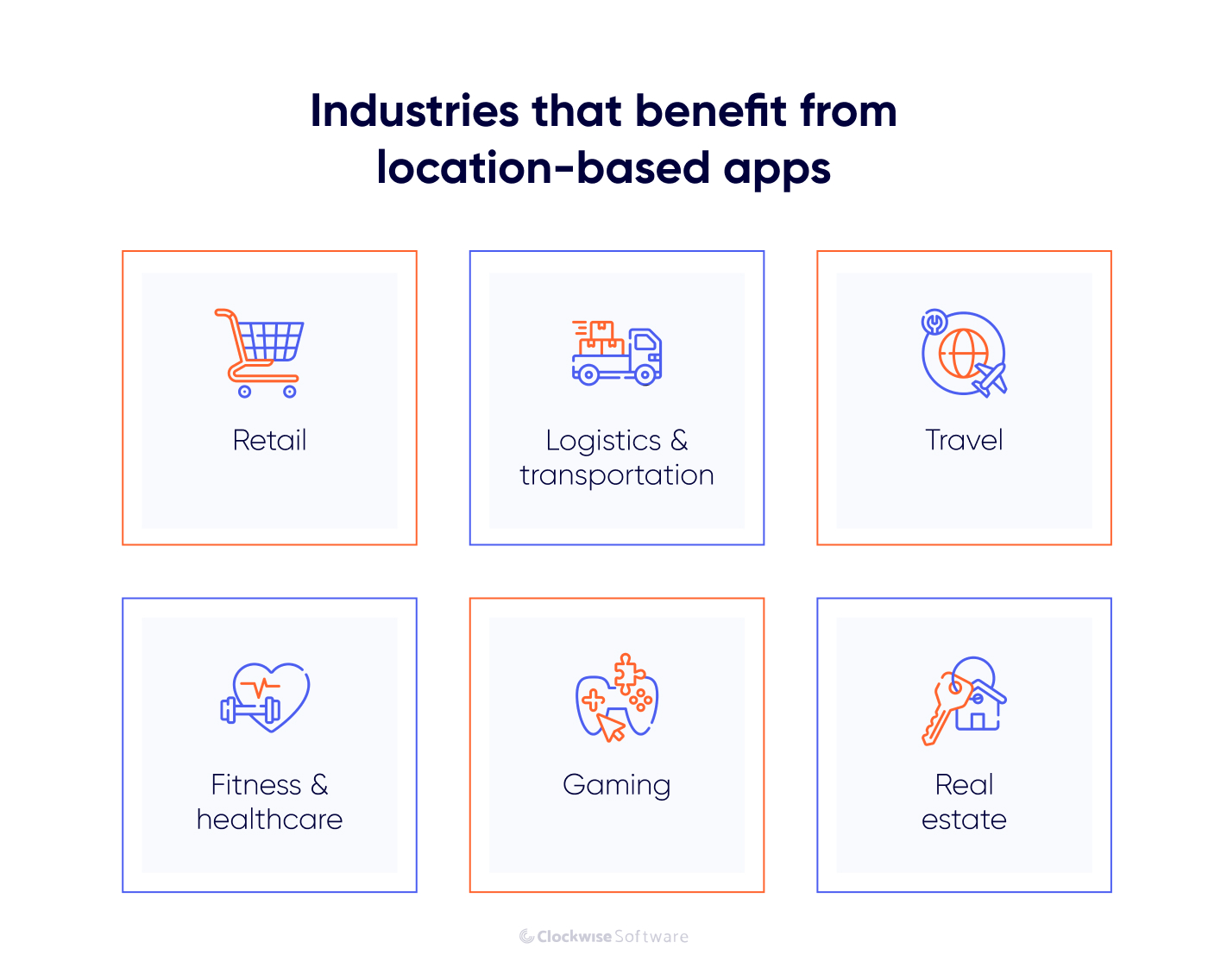
Retail businesses can significantly improve customer satisfaction, reach new customers nearby, and increase sales revenue using location data.
For example, in an app like Instacart, you can use data on users’ locations to show the closest stores to them at the top of the list and calculate an approximate delivery time. This feature saves users’ time and help them decide where to order.
Location-based features are also essential for stores that offer the in-store pickup option. A customer uses a location-based eCommerce or retail app, buys a product, finds the nearest physical shop, and goes to pick it up. For example, Publix offers curbside pickup and in-store pickup for users who order through the Publix app. A user can choose the nearest store based on their location and pick up their order at a convenient time.
Geofencing is another technology that can help your retail business. Use geofencing to trigger push notifications when your app user walks near your store to inform them about current special offers.
Geolocation features can take logistics companies and fleet management solutions to a new level. When you build an app like Uber for Trucks, you can provide shippers with a real-time tracking feature that shows the precise location of their cargo and calculates its time of arrival at a destination point.
The same method works for public transport apps. Citymapper app for public transport tracking operates successfully in numerous cities worldwide. Users just open the app and find out when exactly their bus arrives!
Navigation and route planning solutions that help to track fleet movement and optimize routes using real-time road data are also essential for logistic companies. For example, in one of our projects, a route planning solution, we used the capabilities of Azure Maps for route planning and real-time navigation to create a convenient tool for public transport drivers to find the optimal route and get real-time information on changing road conditions.
A hotel booking app with no geolocation features has no chance to survive. Travelers need a map describing where they stay, a hotel’s proximity to various amenities, and how to get there. Additionally, it’s much easier to look for a place to stay using a map that features all available hotels in a certain area. Just look at the most popular websites like Booking: geolocation features play a significant role there.
That’s why travel app development relies heavily on real-time location data, interactive maps, and smart routing to deliver a seamless user experience. Whether users are searching for accommodations, nearby attractions, or local transportation, these features are a must-have for any competitive travel solution.
Those who take care of their health (or have medical prescriptions to start doing so) appreciate geolocation functionality, too. Whether you are running or cycling, precise data about how many miles you’ve passed today is important and useful. Combined with other technologies, it can shake the market. For example, Runkeeper, the fitness tracker app, even builds training plans for users, taking into account various factors, such as weather forecasts, in users’ locations.
The entertainment industry and gaming can profit from a location-aware app, too. That’s a way to add something new to the old yet boring games and launch a new exceptional app. Remember how popular PokemonGo was?
Another great example is Geochaching — a treasure hunt game played by millions of users worldwide. GPS is the core technology used for this game, as players use GPS devices to hide and find geocaches around the world.
The Clockwise Software team has developed a location-based chat product for Geocaching, the Lilypad app. In this project, we implemented real-time user location tracking and visualized users on a map in clusters for convenient search of users nearby.
You’ve probably heard about the three most important factors to consider when evaluating a property: location, location, and location. Whether it’s an investor looking for a new asset to their portfolio or a family who wants to buy a new house, they all want to know about the area where a property is located, amenities nearby, and other location information.
Almost every multiple listing service or real estate marketplace provides interactive maps with visualized property listings that simplify search and give users more insight into the area where a property is located.
ERP systems for real estate can also include location-based features that simplify market analysis and help make data-driven decisions. In one of the projects we worked on, a real estate management analytics platform, we implemented a map with visualized listings for convenient property search.

Overall, real estate businesses can use location data to enhance day-to-day operations and provide better customer services.
We believe that location-based app development can benefit any business. The key to success is to define what features will meet your users’ needs.
Depending on the industry your app will serve, its specifics, and your requirements, the list of features may be massive. But the point is to start with minimum costs and effort. Here, we present you the basic functionality to consider when developing location-based apps:
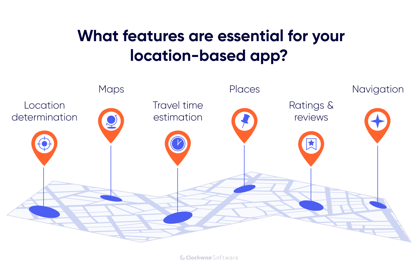
User location positioning is crucial for a location-based app. This data allows you to recommend the nearest shops, best restaurants, or bookstores in the neighborhood, as well as provide on-demand services and so much more. Just look at delivery services like Uber Eats or Postmates: how many troubles would appear if people had to explain their current location via phone?
When starting your location-based app development process, focus on functionality for location determination. To deal with it, your engineering team will use a specific application programming interface (API). Some of the popular tools are:
APIs effectively use the information obtained from GPS, Cell ID, and WiFi networks to determine the precise user’s location.
How to use it for your app: Let users share their location with others or with your app. For example, in messengers, add the Share the Location feature to allow users to see each other’s locations. Or, in a retail delivery app, use real-time location detection to recommend the nearest stores to a user based on their location. Help them find what they want quickly and with minimum effort.
A detailed, up-to-date map is vital for your location-aware app. Take a look at Maps.me: you are aware of your current location, you see a plan describing the neighborhood around you, and you can choose your destination and get precise instructions on how to get there.
Maps can be used in many other solutions less obvious than navigation apps. To find an example, you can explore our online marketplace development case. In this project, we implemented a map that visualizes the location of various creative content producers so users can easily find and hire suitable specialists near them.
Google Maps APIs are among the best choices for implementing a map in your application. They work well on any mobile platform and are familiar to most users worldwide. In 2018, Google Team launched some significant updates and introduced the entire Google Maps API Platform.
Our core APIs work together to provide the building blocks you need to create location-based apps and experiences. One of our goals is to evolve our core APIs to make them simpler, easier to use, and scalable as you grow.
says Google Team
Besides, engineers use Open Streets API, Mapbox API, or similar APIs and frameworks for geolocation app development. The same tools can be used to create custom indoor maps, which are useful for visualizing buildings such as shopping malls, event halls, libraries, and museums.
How to use it for your app: Add interactive maps with custom layers and objects. For example, if you want to build an event app, indoor maps that visualize indoor environments and outdoor maps that help users see upcoming events nearby can be great features to enhance customer experience and distinguish your app from competitors. You can also make your apps available offline — this feature can be useful in travel apps, which users frequently need to access without a stable internet connection.
It’s hard to imagine a location-based app without places. Depending on your industry and the app’s goal, put cafes and restaurants, theatres and churches, monuments, and other points of interest on the map. Augment each place with general information, accurate addresses, contact details, visitors’ reviews, and the ability to build a route to reach it. More advanced functionality may also include Street View. Have a look at Foursquare. This app provides recommendations about places, cafes and restaurants, parks and exhibitions, etc., near the user’s current location.
Places API is a tool to access the vast Foursquare database. With more than 105 million places, it’s a powerful API to opt for when adding places to your geolocation app. If you prefer Google products, Google Places API is another tool with a huge community and detailed documentation that you can use for location-based app development.
How to use it for your app: Think about what places your users need to know about to be satisfied with your services. When building a food delivery app, you will need to put all cafes and restaurants on a map, while for a real estate marketplace, it can be useful to provide a map with visualized property listings.
You can also add a geotagging feature to your app, allowing users to pin locations to their photos, videos, and other content. It will work great if you plan to create an app like Instagram: look how many people pin locations to their posts, stories, and reals!
Navigation and routing are some of the most demanded features for location-based app development. Logistics software, delivery services, travel apps, fitness apps, and many other solutions need navigation features to satisfy users’ need to find the right direction and track their movement. Along with providing a detailed route, your app can recommend alternative routes to avoid traffic jams or crowds, or routes that include the most places of interest.
Google Maps Directions API and Google Distance Matrix API are some of the tools to utilize for navigation functionality development.
How to use it for your app: Let users add a starting point and their destination on a map to find the best route, implement turn-by-turn navigation instructions to help users navigate on the road, and make it possible to dynamically adjust a route based on traffic data, unexpected hazards, etc.
Can you remember those times when you needed to wait for your taxi on a cold, empty, dark street for half an hour? It started raining, and you had no umbrella. The weather, the mood, and the neighborhood looked terrible, and all you could do was wait until the taxi finally arrived.
Now, with services like Uber, you can leave your apartment right the minute before your cab arrives. Estimated arrival time is a feature your app’s users will love. Are they expecting their food to arrive? Are they estimating when to depart to the airport to be there right at the check-in time? The travel time estimation feature will be of great importance in many cases.
How does it work? A location-aware app tracks your up-to-minute location, analyzes real-time data on road traffic conditions, calculates the approximate speed, and, depending on the distance, provides time estimations.
How to make a location-based app with travel time estimation? The APIs we’ve mentioned before, Bing Route Data API, and similar tools will serve you well.
How to use it for your app: You can implement a travel time estimation feature to provide users with an approximate time for their delivery arrival. Let your app automatically detect queues, traffic jams, or possible car incidents to calculate how long it will take to get from one point to another. Here’s how Google does it: The app analyzes the number of smartphones connected to the network in a particular location, how fast they are, and in which direction they move. This helps estimate traffic conditions or shopping mall congestion.
Location-based apps are of great importance for customer service evaluation. For example, based on places you’ve visited, Google can ask you to rate or review a popular café or a gym nearby.
How to use it for your app: if you are an entrepreneur planning to improve your business with a location-based app, this feature will work well for you. Collect feedback from real customers. Once an app detects a customer has left your store, send push notifications asking them to review and rate your business. It will help you find new ways to improve your products and services.
These features, along with the sign-up/log-in feature and user profile page, can be the basis of your app. Other features depend entirely on the app’s specifics, and later, you can add push notifications, travel history, and other improvements your users would prefer.
Now, let’s explore how you should approach location-based app development to succeed.
The way you structure the development process can have a direct impact on the success of your app. That’s why you need to know about the essential steps in custom software product development and the most cost- and time-effective ways to approach this process.
Below, we share a step-by-step guide on how to create a location-based app based on our experience developing software solutions.
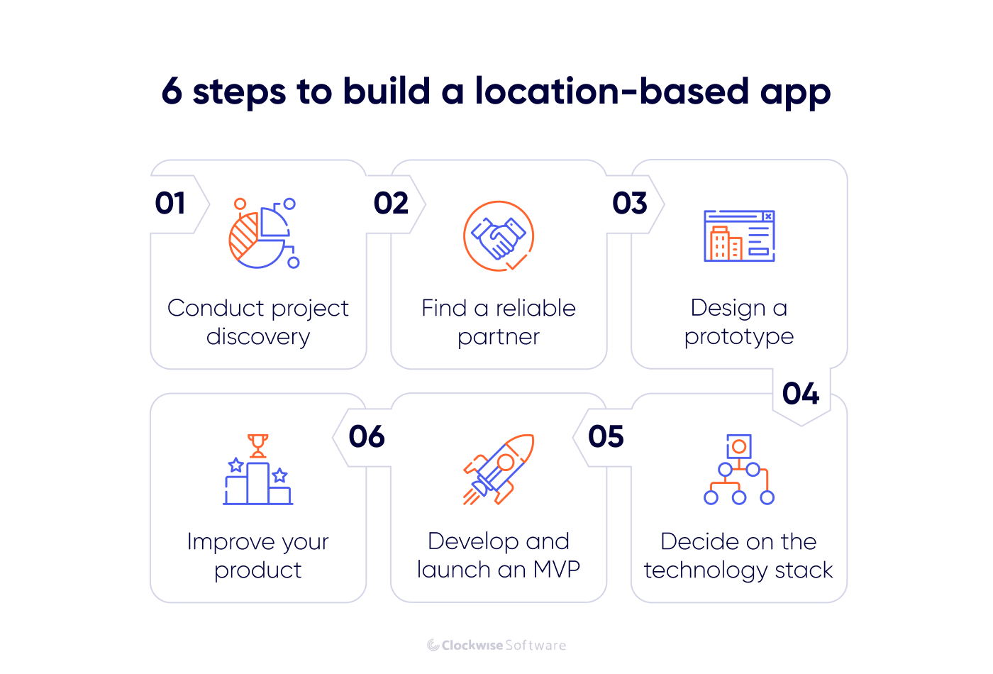
Whether you want to create a startup or augment your existing business with a location-based app, the development process should start with project discovery. Project discovery is a stage when you:
By conducting project discovery, you form a clear vision of your product and understand the scope of work to be done and the investments required for location-based app development. This stage is also a part of risk management in software development, as you have a chance to explore all nuances of your product vision, identify risks, and come up with a mitigation plan.
If you don’t have experience conducting a discovery phase, it’s better to involve skilled specialists. A business analyst, project manager, designer, and software architect will help you prepare for development in the best way.

Consider starting the discovery phase with the same team that will execute your project development. In this way, you can get the accurate timeline and cost estimates and ensure that your team understands the specifics of your project.
But how do you choose a development team? What specialists do you need? We have some recommendations for you.
When defining who will work on your geolocation app development, there are three essential things to consider:
Typically, app development requires having the following specialists:
As we mentioned above, a business analyst, project manager, UI/UX designer, and software architect should be involved in project discovery. An experienced software engineer or CTO can play the role of a software architect, but it’s important to have someone who can make reasonable and effective technical decisions.
After project discovery, you can define a precise team structure and choose software engineers and QA engineers based on the chosen functionality and architecture.
You can choose to develop in-house or outsource development to logistics software development company.
In-house development is a great option if you favor direct control over the development process. However, you need to know what talents to hire to meet your project needs and be ready to invest time and money in recruiting, training, and onboarding. At the same time, your commitment is increasing: whether product development goes smoothly or not, you need to pay your team and provide benefit packages.
By choosing software development outsourcing, you can stay more flexible and put less effort and time into the development process. You will still participate in decision-making and stay informed on your project’s progress, but you don’t need to manage your team and get into details of project execution, as well as pay a team if a project stops. This cooperation model is cost-effective and allows you to focus on high-level business tasks while the outsourcing team, proficient in geolocation app development services, works on delivering a product that meets all your requirements.
For geolocation app development, it’s better to choose a team with relevant experience. If your technical partner has already worked on location-based apps, they know what technical decisions work the best and can choose the most appropriate way to implement your idea from the start, reducing the chances of failure or reworks.
Before choosing a technical partner, look at their skills, core expertise, and portfolio. If a team has experience working on a project in your niche or building solutions with similar features you want to implement in your app, prioritize them over those with cheaper pricing but no relevant experience.
Design plays a crucial role in making your app successful. A good design makes your app intuitive and easy to use, which makes your users love your product. Thus, in this stage, a UI/UX designer works on creating a prototype of your app, deciding on the design of interface components, their placement, color palette, etc.
Typically, this stage takes 1-2 weeks and can overlap with a project discovery stage. During project discovery, a UI/UX designer may create low- or high-fidelity wireframes and then turn them into a clickable prototype.
A prototype is your chance to test the concept before hard work starts. Besides the design decisions, a prototype visualizes user flows and helps to evaluate your app’s usability. Thus, moving to the development stage, you can rest assured that your team build a solution with a convenient interface and well-thought-out logic.
Another task to do before development starts is to analyze the desired functionality and decide on technologies.
Providing a seamless cross-platform experience is a must. Your geolocation app should look and work impeccably on any platform, OS, or device. Here are some technology options you can consider:
You also need to decide on tools for implementing location-based features. We’ve mentioned several popular APIs and toolkits, such as Google Geolocation API, Azure Maps API, and Mapbox API. Let your engineering partner come up with suggestions. Developers you work with have experience in various directions with many technologies and products. They can analyze your requirements and offer the best tools to bring your idea to life.
How do you approach geolocation app development the right way? Start with a minimum viable product (MVP).
MVP is a tried-and-tested way to roll out a solution fast, with minimum costs. The concept is based on building a simple version of your app first, implementing only core functionality enough to cover users’ key needs, and launching it to test the idea on users. It is a way to attract investments, collect users’ feedback, and proceed with upgrades and new features based on real feedback, not just hypotheses built through market research.
Start attracting first users and drawing the attention of people who can invest in your product growth. Also, think about your app monetization strategy: you may start with a freemium, subscription-based pricing model or provide your app for free but increase its revenue through an effective marketing strategy. Overall, MVP is your chance to market early, gain valuable feedback, start monetizing with minimum effort, and find the right direction for further improvement.
Don’t ever listen to people who say it (the product) is good enough because it never will be. Building a great product is a fluid, ongoing process.
This quote from George Berkowski’s book How to Build a Million Dollar App has taken us to the last but neverending stage of product development.
Marketing, functionality upgrades, and design improvement never end. The collection of user feedback and continuous app improvement are the secrets of how to create a location-based app that will succeed. After the MVP launch, it’s critical to identify what works not as expected and consider ways to fix issues based on user feedback. Listen to your users and adjust functionality, redesign your app, work on speed optimization, or simply fix bugs.
Just take a look at Uber: This location-based app started in 2009. More than 6,000 software engineers work on Uber products today. Even though the company is one of the unicorns, with $1.887 billion of annual net income in 2023, it keeps improving its software products to maintain its leading position.
Location data is essential for providing personalized services and making software more convenient. Depending on your goals, there are numerous ways to use location data and turn it into features, from navigation and routing systems to marketing tools such as geofencing.
Geolocation app development isn’t a piece of cake. As with any software development project, it requires thorough preparation. Who will build your app is also essential and can impact your software’s quality and cost. Cooperating with a team experienced in location-based app development may help you avoid many problems and get the results you expect. Once you have found an engineering partner to rely on, you can focus on product growth and reach the desired positions.