Route planning solution for a technology company

Our team contributed to the discovery and development of location tracking and route planning software for a company that provides technology solutions for various businesses.

Country:
United Kingdom
Industry:
Logistics
Time frame:
July 2022 – April 2023

High-quality route planning software is significant for public transport, allowing for efficient resource use and reducing road incidents. With the right software solution, we can make our roads safer. This is the task we worked on during this project.

Project Background

Foresolutions, a technology company that provides efficiency improvement services for multiple businesses, requested our software discovery and development services to launch a logistics app for public transport in London and urban areas. Our client had an up-and-running, full-featured platform for efficient route planning.

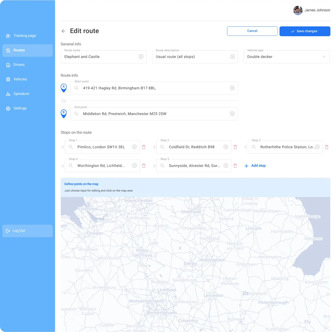
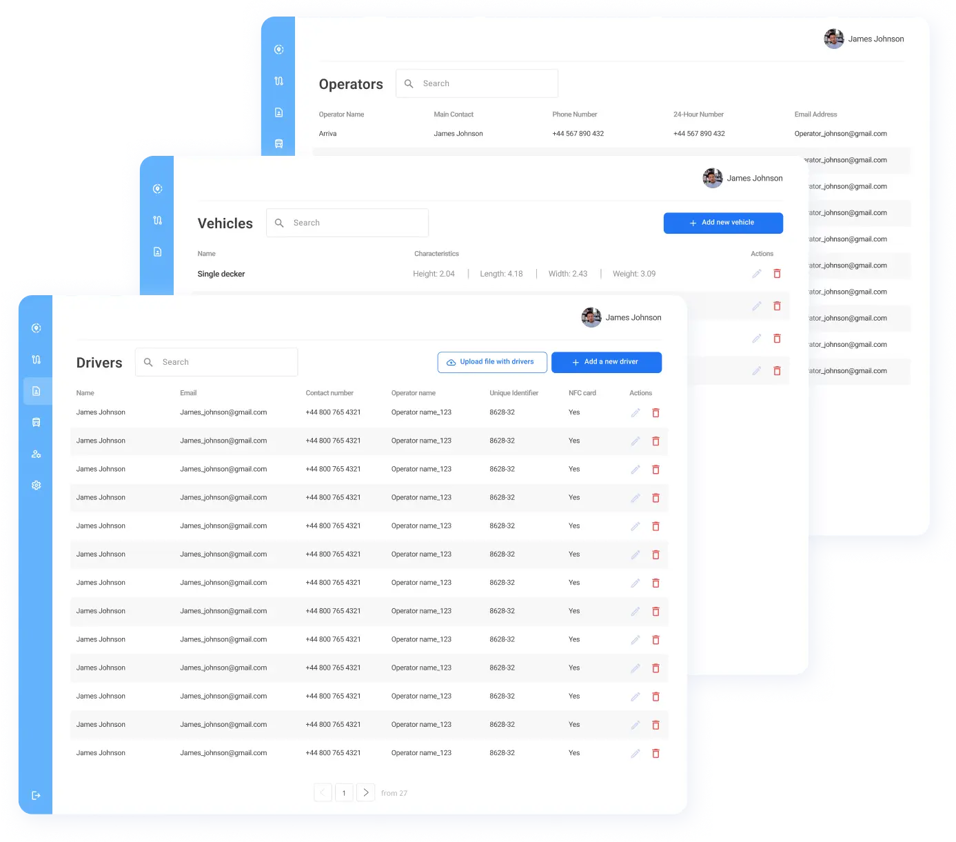
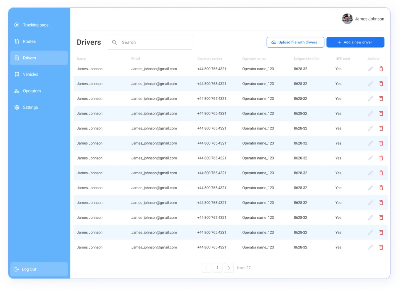
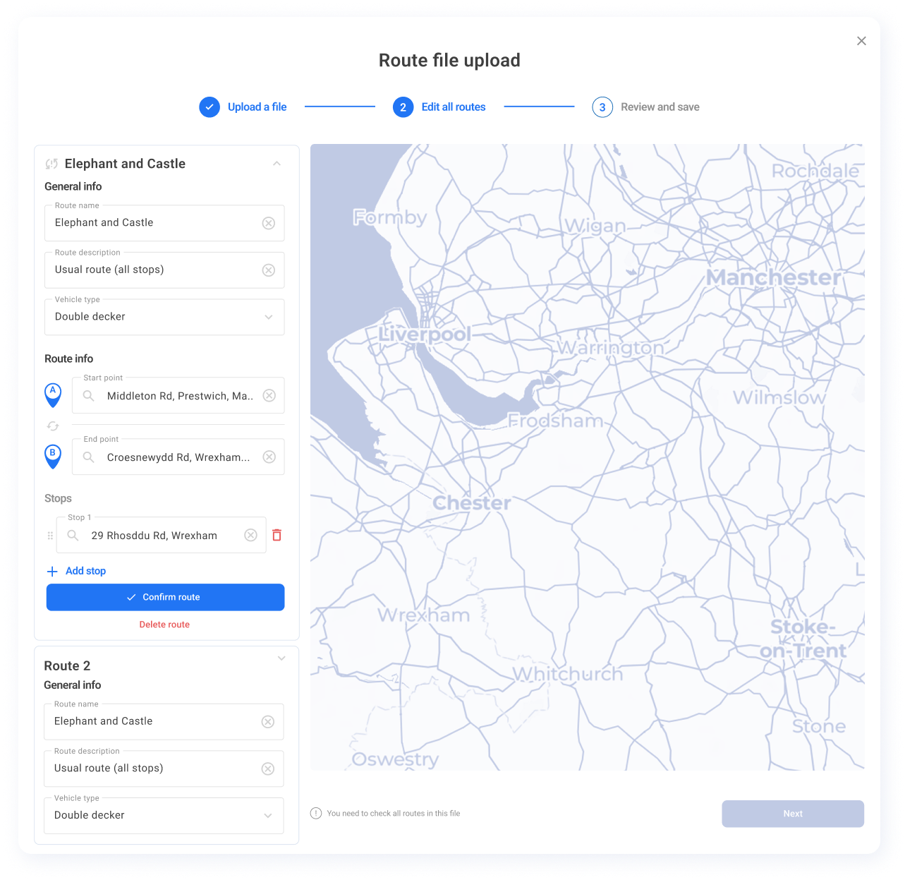
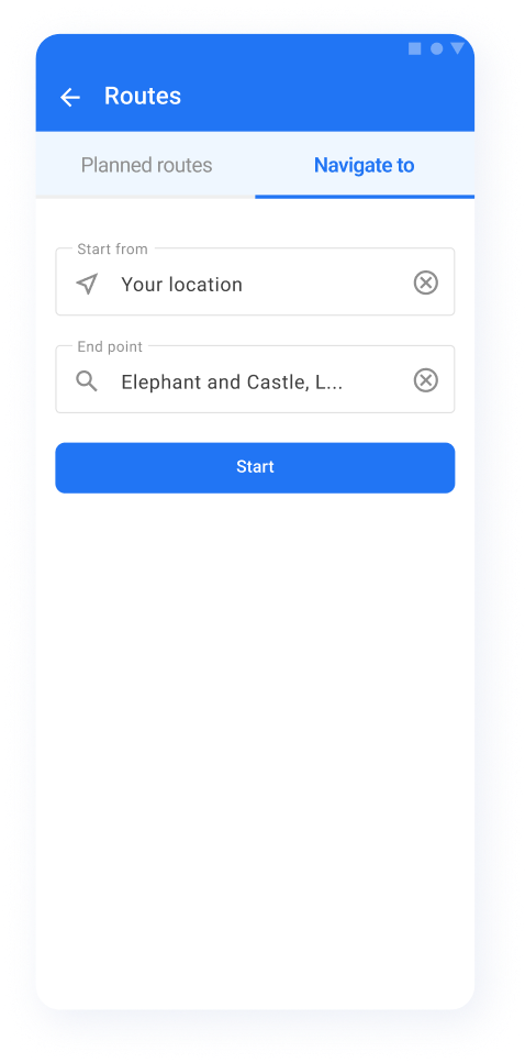
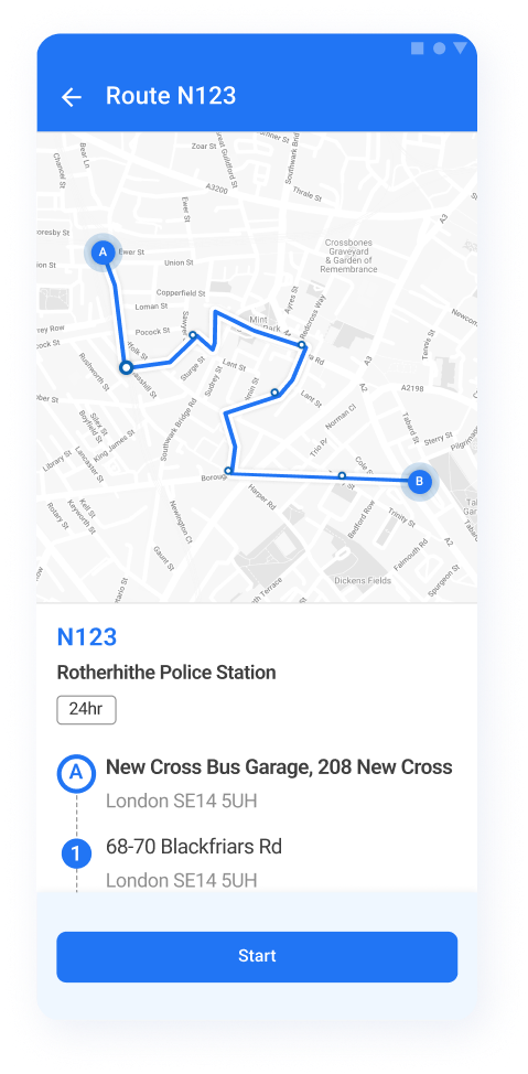
The goal was to develop a new module for this platform, integrate it with third-party services like Azure Maps, and use it as the basis for a mobile app and a web admin platform.

To ensure the technical feasibility of the planned software, avoid potential risks, and launch new, error-free functionality fast, Foresolutions chose Clockwise Software as a reliable service provider with proven experience developing location tracking software.

Project BackgroundProject Background

Discovering the product

Transportation companies operating in this area noticed critical limitations in available software: most existing navigation apps didn’t account for impassable routes, low bridges, and other hazards that pose challenges for drivers. These challenges may lead to delays, incidents, and even casualties. A product offering broader functionality and meeting currently unmet needs would help to decrease the number of casualties and contribute to transportation companies’ reputations and overall revenues.

To develop a solution that would fully meet our client’s requirements and expectations, we had to:

01

Ensure the technical ability to integrate with third-party tools like Azure Maps, government databases, and the Foresolutions location tracking platform

02

Develop a plan to implement requested functionality and make it simple, intuitive, and user-friendly

03

Detect risks and challenges the engineering team may face when developing, launching, and improving the software

04

Receive labor union approval for further development and the product’s launch

This is why we started with a project discovery phase, during which we:

Created critical documentation for the project and focused on medium fidelity prototypes. These deliverables were essential for for both discovery phase and project development.
Validated prototypes and the proof of concept, which embody critical parts of functionality, allowing us to ensure the whole idea was technically feasible and get approval from the labor union.
Considered numerous potential challenges related to product development and implementation, taking actions to mitigate possible risks and laying the groundwork for further solution development.

With project discovery deliverables in our hands, we launched a development stage and built a mobile application for drivers and a web platform for operators.

Product development stage: challenges and solutions

This project required deep expertise in integrating third-party services, location tracking, and routing optimization. Together with a Foresolutions project manager and software architect, our team identified several critical product development challenges, developed a plan to handle them, and successfully implemented actionable solutions to these challenges in a mobile app and a web platform.

Challenge #1

The end product should meet the needs of multiple categories of users — drivers, operators, administrators, and managers. Each group should have access to specific functionality and route data.

Solution

We implemented role-based access to the mobile app and platform: depending on users’ roles and the department or team a user represents, they may view, use, and modify only particular features and limited department-specific data.

Challenge #2

This software product serves multiple groups of users. We had to develop features that allow for both adding users and importing them from external databases using CSV files. Along with standard fields, CSV files contain conditional fields that may or may not be filled for different organizations or groups, complicating user validation.

Solution

During the project discovery phase, we had to investigate user roles and conditions for assigning certain roles. Based on this investigation, we developed an approach that let us quickly validate data from CSV files on the app’s front end and made importing user data fast and simple.

Challenge #3

One of the crucial things we had to enable was seamless authorization for drivers. It was essential to make the process effortless and error-free and to minimize data entry steps.

Solution

We developed functionality for simple authorization using near-field communication (NFC) technologies. Every driver can now log in to the system within seconds just by tapping a small plastic card on a smartphone.

Challenge #4

One of the challenges for the London transport system is optimizing routes for massive vehicles like double-decker buses. These types of vehicles don’t fit under low bridges, significantly limiting the number of routes they can take. Numerous requirements for efficient software originate from this challenge.

Solution

We used the capabilities of Azure Maps to optimize route development and solve this challenge. Based on a vehicle’s type and size, the driver is shown a safe and suitable route.

Challenge #5

To ensure smooth and efficient operations, platform admins should be fully aware of the real-time situation on every route. Operators need to receive and view real-time information about vehicles, their types and locations, active drivers, congestion on routes, and other important information.

Solution

Our engineering team ensured an uninterrupted data flow from the driver’s mobile app to the application’s back end and to a web platform to allow real-time data exchange between operators and drivers.

Challenge #6

Route hazards may lead to schedule changes, delays, and even casualties. It was crucial to ensure drivers know about and can avoid possible hazards.

Solution

With implemented functionality, operators can import existing hazards from third-party databases and manually add them to the map; drivers get information about hazards as they are added.

Challenge #7

In the future, this app may help numerous transportation companies in the United Kingdom and all over the world make public transport faster and safer. Thus, the app’s architecture needed to be scalable and suitable to serve as the basis for a white label app.

Solution

We built this project with a white label product in mind.

The app’s architecture follows multitenancy principles. This makes it possible to scale and adjust the product to different organizations’ needs. Additionally, the app’s interface consists of easy-to-modify modules, so both the front and back ends may serve the needs of new organizations.

Features we implemented

During the development phase, we implemented the following functionality in the admin web platform and the React Native mobile app for drivers.

Web platform:

Live location tracking
One of the core features allows platform admins to receive real-time data about vehicle locations.
User management
Users with administrator’s permissions can add, import, and delete user data.
Route management
Admins can create and edit routes directly on the map, as well as add, delete, and replace stops along a route.
Hazards management
Platform functionality allows admins to add, delete, and import route hazards.

Mobile application:

Route line navigation
One of the app’s key features allows for displaying routes on a map and navigating with the app’s instructions.
Turn-by-turn instructions
Drivers can view and follow detailed route instructions via the mobile app.
Hazard alerts
Drivers are instantly notified when they’re approaching a potential hazard.
On-demand navigation
Drivers can build custom routes and use in-app’s navigation.
Live location tracking
The application collects data on the real-time location of each vehicle.

Team

React
UX/UI
Designer
Frontend developer
3 Frontend
developers
QA Engineer
QA
Engineer
React
Project
Manager
React
Business
Analyst

Technologies we used to develop the web platform’s front end:

React
React
React query
React query
React hook form
React hook
form
Azure Maps
Azure Maps
Azure DevOps
Azure DevOps
Material UI
Material UI
Sentry
Sentry
Application insights
Application
insights
TypeScript
TypeScript

Technologies we used to develop the mobile app:

React Native
React Native
Redux Toolkit
Redux Toolkit
React hook form
React hook
form
Azure DevOps
Azure DevOps
Azure Maps
Azure Maps
Maplibre
Maplibre
Auth 0
Auth 0
NFC
NFC
Zod Form
Zod Form
Sentry
Sentry
Application insights
Application
insights
Turf.js
Turf.js
Norifee
Norifee

Project outcome and future plans

The product is now live! Beta testers (real London bus drivers) are performing test rides and evaluating the app’s functionality and usability.

The company that uses this software expects a substantial decrease in injuries to people resulting from public transportation in the UK; additionally, they are collecting feedback from beta users and generating ideas for the product backlog to ensure further improvements to both the web platform and mobile application.

Would you like to elevate your business with a powerful location-based solution?

Fill out this form and let's talk about your needs.
By submitting this form, you agree to Clockwise Software Privacy Policy.